So far we've looked at:
- Expanding the downtown grid west into Oliver on 100ave
- Continuing that through the Brewery District and into Westmount
- Improving the existing 110st and 111st contra-flow lanes near the University
- Imagining a UofA Minimum Grid - Part 1
- Imagining a UofA Minimum Grid - Part 2
Here we're going to look at adding a cycletrack to 109st, on the southside of the river. This is near the University, and it could be considered part of the UofA grid, but the city has a separate project called Envision 109, and so I'm going to break this out separately.
According to the city, this is what Envision 109 is about:
Planning studies have been carried out to revitalize the corridor over the past decade. The 109 Street Corridor Area Redevelopment Plan, approved in 2013, suggested that a Comprehensive Streetscape Improvement Plan be developed to review the function of the corridor, to improve the pedestrian environment and to help revitalize the adjacent areas. Streetscape improvements will be built in stages as funding is available.Lets see what we can do about that.
Warning: this is all complete make-believe, but it doesn't have to be.
109 Street & 87 Avenue
The first thing to notice about 109st is that there is a northbound bus/tax/bike lane on the east side of the street. And in all of these images, I've replaced that with a 2-way cycletrack.
I don't think that cycletracks should be a zero-sum game, where people on bikes gain while people on transit lose. But in this one specific case I think there's a good case for it, because right now the buslane is only used by one major route - the #9.
I assume that before the South LRT was completed this buslane was much busier? But today this is a very quiet buslane compared to similar ones on Jasper (which are being removed) or 97st. I don't know how this will change with ETS' recently announced new strategy, and I also don't know if it will change after the Millwoods LRT is complete. But for right now, converting that underused buslane would be a quick-win.
109 Street & 86 Avenue
How. On. Earth. Is. This. An. Unmarked. Crosswalk?
This is an elementary school. This is a university area. This is a commercial mainstreet. The only reason that this intersection is built like this is to discourage people from legally crossing the street. It's time for Edmonton to grow up.
Here again the buslane has been replaced with a 2-way cycletrack. A crosswalk has also been added, along with a curb-bulb in the westside parking lane to shorten crossing distances.
By the end of this summer every intersection on 109st from 82ave to 88ave will have a full set of traffic lights - except for this one. So it might actually be better to just skip the crosswalk, and to jump straight to traffic lights. Curb-bulbs in the westside parking lane should be installed all along 109st, though.
109 Street & 83 Avenue Cycletrack
This summer the city will be installing a cycletrack at 83ave. Here our imaginary 109st cycletrack is connecting to it.
109 Street & Whyte Avenue
At Whyte Ave we lose a rightturn lane. The traffic signals would need to be modified so that leftturning vehicles would not be turning across the cycletrack while people on bikes have a green light. That would mean the addition of a no-left-turn-on-double-red, but the city is moving towards those as part of Vision Zero anyway. This would also increase safety for people walking across Whyte.
109 Street & 76 Avenue Cycletracks
At 76ave our imaginary 109st cycletrack would connect with the newly-improved cycletracks that are being installed here this year.
South of Whyte Ave 109st is really wide - alternating between 3-lanes of traffic each way, and 3-lanes of traffic each way plus a leftturn lane.
The city wants to make this area more inviting, and that's what we have here:
- one lane is converted to a 2-way cycletrack
- one lane is removed, and the sidewalks are widened on both sides of the street
- that leaves 2-lanes of traffic each way, and in some cases also a leftturn lane.
This could continue all the way to about 62ave, where things get complicated. But with some creativity it might even be possible to take it further south.
The Updated Map
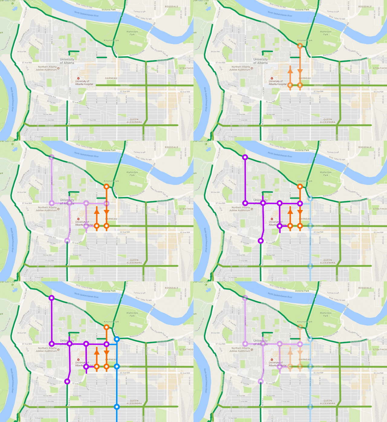
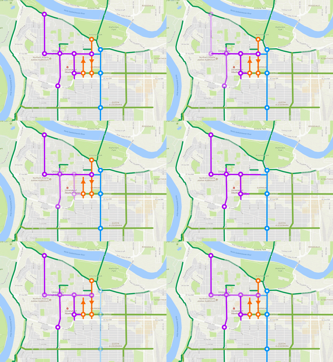
In this map the darker green lines show older, reasonably high-quality cycling infrastructure. The lighter green lines are what is being installed this year: the 83ave cycletrack, and the 76ave/106st improvements. The orange lines are some quick-wins that we looked at for 110st and 111st. The purple lines are a UofA minimum grid, which requires removing leftturn lanes from 87ave, 112st & 114st. And finally, the blue line is 109st.
Is this overkill for a "minimum" grid? Do we need high-quality, all-ages-and-abilities cycletracks on 106st, 109st and 114st? (would anyone ask that question about all of these roads that we've built?)
I think there's a good case to be made for a cycletrack on 109st:
- replacing the underused buslane makes it is a reasonably quick-win
- it connects much further south than can easily be done on 110st, 111st or 112st
- it aligns with the city's Envision 109 goals
To end things off, here's one more look at the map. In this version the segments disappear one-by-one, to give a sense of what each piece adds to the overall network:


1 comment:
Greetings! I've been reading your web site for some time now and finally got the bravery to go ahead and give you a shout out from Dallas Texas! Just wanted to say keep up the fantastic job! automated pipe welding
Post a Comment